History tells us that all lands East of Bass River belonged to the Nauset Tribe, but most of present-day Brewster was home to the Sauquatucket people and was called Sauquatucket.
The northeast section of town was home to the Namskaket tribe. It was customary for both the Namskaket and Sauquatucket to camp inland in winter and move along the estuaries (Paine’s Creek and Namskaket) toward shore in summer. For the Sauquatucket, the migration of the herring from Cape Cod Bay to the Mill Pond was their signal to begin their own migration.
In 1619 Thomas Dermer, who was a navigator employed by Sir Ferdinando Gorges, visited Sauquatucket. He brought with him Squanto of Patuxet (now Plymouth) to explore for fertile ground, but apparently, they did not find what they were looking for, as they did not stay long. But soon enough the English established a colony at Plymouth and migrated down to the Cape penninsula to stay.
The Native Peoples, who were acutely aware of the landscape and how to use it to survive, taught the English much about this land. Corn became the colonists’ staple. In fact, it is unlikely that any of the Plymouth Colony would have survived if they hadn’t stolen a cache of Native corn when they first arrived and later been taught how to plant it.
The whales that stranded along this shore were a source of food for the Native Peoples, but became a valuable source of oil for the colonists. Present day Route 6A follows an ancient Native foot path that was well established before the arrival of the colonists. Present day Millstone Road was a well-traveled North-South corridor. Long Pond (called Mashpa) and Sheep Pond were also food sources.
On June 24, 1653, most of present-day Brewster from Cobbs Pond to Namskaket Creek was purchased for the sum of fifty-eight pounds sterling from sachems Wono and his son Sachemas by Thomas Prence and William Bradford on behalf of Plymouth and its partners. The area not yet incorporated as its own township, the western section fell under the jurisdiction of Yarmouth and the eastern section under Eastham. (Dennis and Orleans were not yet incorporated as separate towns).
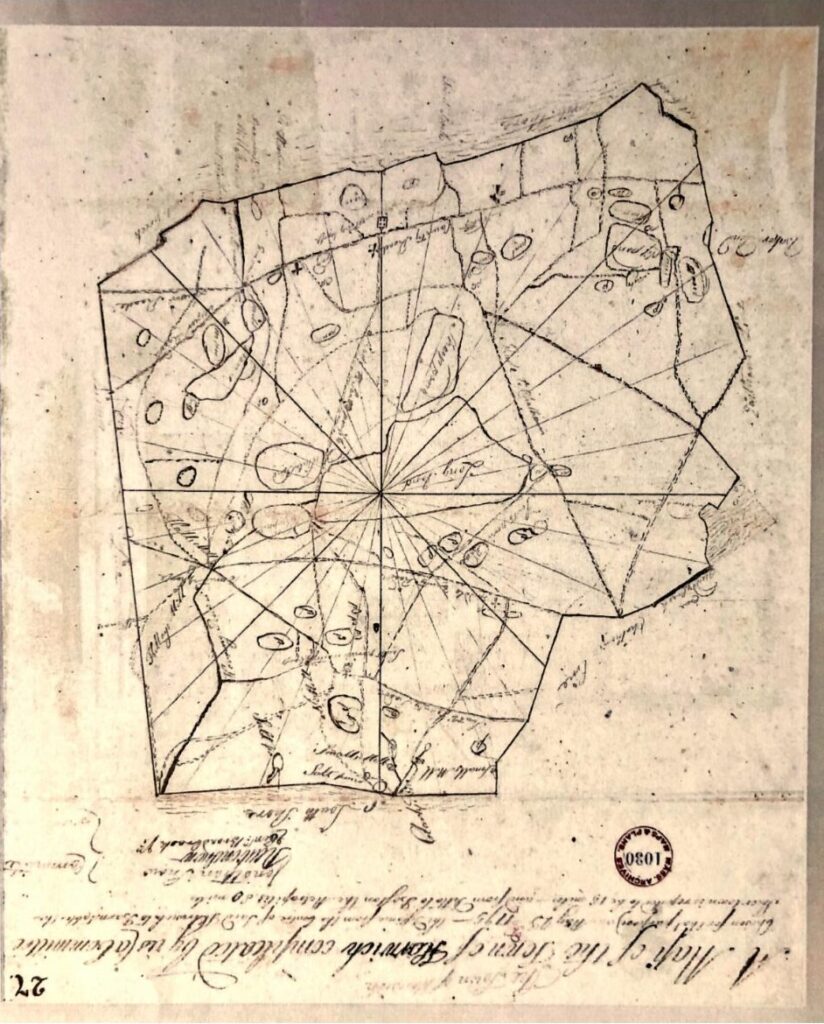
Around 1663 Governor Thomas Prence constructed the grist mill on what was known as the Satucket River (now Stony Brook), which ground corn for Native and English alike from towns as far away as Eastham. In 1694 “The Satucket Lands” as they were then called were incorporated as the Town of Harwich. (See map below – North is at bottom). The lands ran from Namskaket Marsh (then the bound for Eastham) to Quivet Creek (then the bound for Yarmouth) and from “sea to sea” (Nantucket Sound to Cape Cod Bay). In 1803 the North Precinct of Harwich petitioned for separation and became the Town of Brewster.
As less and less of the land was available to the Native Peoples for hunting and gathering, they sold more and more in order to get by, and the tribes got pushed onto smaller and smaller parcels. The last full-blooded Sauquatucket Indian, Rebecca or “Beck” Crook, died in 1818 at age 91 in the home of Phillip Ellis, Jr., her children having pre-deceased her. The last of her lands was taken by the Town to pay for her care during her long decline.

With special thanks to Brewster Historical Society Board member Chris Dudzik. For more from Chris about the Sauquatuckets. (And Marcy for sending around).

